

You have seen them on every long drive: a small stone by the roadside with a coloured top and a place name painted below it. Most websites will tell you the colour shows the type of road. That is true, but almost all of them stop there, and a few get the details wrong.
This article goes to the source instead. That means the Indian Roads Congress standard for these stones, plus the circulars the Ministry of Road Transport and Highways (MoRTH) has issued on top of it. By the end you will know what each colour means, what the rest of the stone is telling you, why some stones do not match what you read online, and who actually looks after the road under your wheels.
What we call a milestone is really a kilometre stone
In daily talk everyone says milestone. On paper, India stopped measuring roads in miles a long time ago, and the official name is kilometre stone. The standard that decides how these stones look is IRC:8, titled Type Designs for Highway Kilometre Stones. It is published by the Indian Roads Congress (IRC), the body that writes most of the technical standards for roads in India. The first edition came out in October 1960, and the version still in use is the second revision, known as IRC:8-1980.
That date sits in the middle of India’s switch from miles to kilometres. Parliament passed the Standards of Weights and Measures Act in December 1956, it came into force in October 1958, and the Railways moved to metric units from 1 April 1960. Before IRC:8, the IRC had a separate standard for highway mile stones. The full story of that change is in our article on the metric system.
One more point before the colours. The IRC is a professional body, and IRC:8 says it was approved by the IRC Council and recommended for use on all roads in the country. It is a recommended standard, which is one reason what you see on the ground can differ from road to road.
What each colour means
The colour is painted on the rounded, semicircular top of the stone. The rest of the stone is white with black lettering. The table below follows the wording of the standards themselves, not the lists that get passed around on the internet.
| Road type | Colour of the rounded top | Who looks after it |
|---|---|---|
| National Highway | Canary yellow | Agencies under MoRTH: NHAI, NHIDCL, state PWDs and the Border Roads Organisation, depending on the stretch |
| State Highway | Brilliant green | The state government, generally through its PWD |
| Major District Road | White | State PWD, zilla parishad or another local body, depending on the state |
| Other District Road and Village Road | Orange | Local bodies and state rural works agencies, depending on the state |
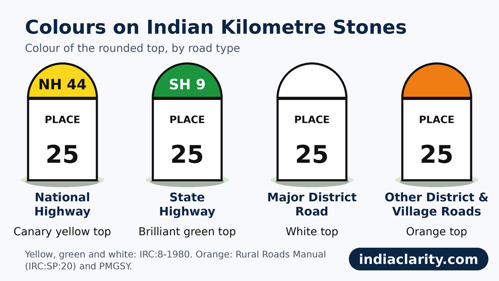
The first three colours come straight from IRC:8-1980. Orange is not in IRC:8. It comes from the Rural Roads Manual (IRC:SP:20), which says a rural road should have kilometre stones of the standard size with the rounded top painted orange. The Pradhan Mantri Gram Sadak Yojana (PMGSY) says the same on its own type-design page: orange tops on both the ordinary and the fifth-kilometre stones.
What about blue and black?
Many websites, mostly exam sites, list blue or black for district roads. I could not find that in IRC:8, which gives white for major district roads, and I could not find an official document that sets blue or black. If you see a blue or black top on a district road, it is safer to treat it as local practice and not as a national rule.
Two small corrections to what you may have read. The coloured part is not a stripe. IRC:8 calls it the semicircular portion, which is the rounded top. And white counts as a colour in this code, so a major district road stone has a white top over a white body.
How to read the rest of the stone
The colour is only the first clue. IRC:8 sets out the rest of the design as well.
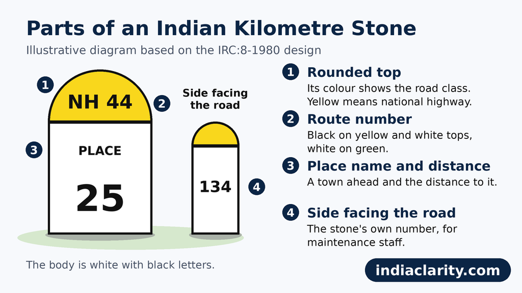
The route number. On stones with a yellow, white or green top, the route number is written on the rounded part. It is black on yellow and white, and white on green.
The place names and distances. The body of the stone carries the name of a town ahead and the distance to it. The order in which names appear is not random on national highways, and the next section explains it.
The stone’s own number. Look at the side that faces the road. That number is the stone’s position along the road. The code says it is meant for maintenance staff. It starts at zero at the starting station and goes up one by one to the last stone at the terminal station. For national highways that pass through more than one state, the Ministry has asked for the numbering to stay continuous across the states.
The material. IRC:8 leaves this open. Stones can be made of locally available material such as hard stone or cement concrete, which is why they look so different from one region to another.
The four kinds of stones you pass
Not every marker you pass is an ordinary kilometre stone. The IRC has a separate standard for each kind.
| Stone | Where you see it | Standard |
|---|---|---|
| Ordinary kilometre stone | Every kilometre on national highways, state highways and major district roads | IRC:8-1980, Plate 1 |
| Fifth kilometre stone | Every fifth kilometre on the same roads, in a bigger size | IRC:8-1980, Plate 2 |
| 200-metre stone | Between kilometre stones | IRC:26-1967 |
| Boundary stone | Marks the edge of the road land | IRC:25-1967 |
On other district roads and village roads, IRC:8 asks for one size only (Plate 3), with no separate big stone every five kilometres. On PMGSY roads the boundary stones are painted orange, while the 200-metre stones are painted white.
Why one stone can carry three languages
On a national highway the language on the stone follows a fixed rotation. A MoRTH circular dated 24 December 2004 laid it down, replacing an older circular from 1981. The zero stone and every fifth stone are the bigger ones, and they carry the name in the local language and again in English, in Roman letters. The stones in between alternate between Hindi and the local language.
Where the local script is already Devanagari, the ordinary stones may switch between Hindi and English instead, and on the bigger stones the Hindi replaces the local language. The numbers are always written in the international form, 1, 2, 3, and never in Devanagari or any other local numerals. IRC:8 gives the reason: Article 343(1) of the Constitution sets that form for official use.
The same circular asked states to follow this pattern on state highways too. It told field offices to rewrite the existing national highway stones by 31 March 2005, and it asked the IRC to amend IRC:8 to match. Older stones can look different from the pattern above because the earlier rule, which allowed Hindi or the local language, was in force before.
Where the stones stand, and why on the left
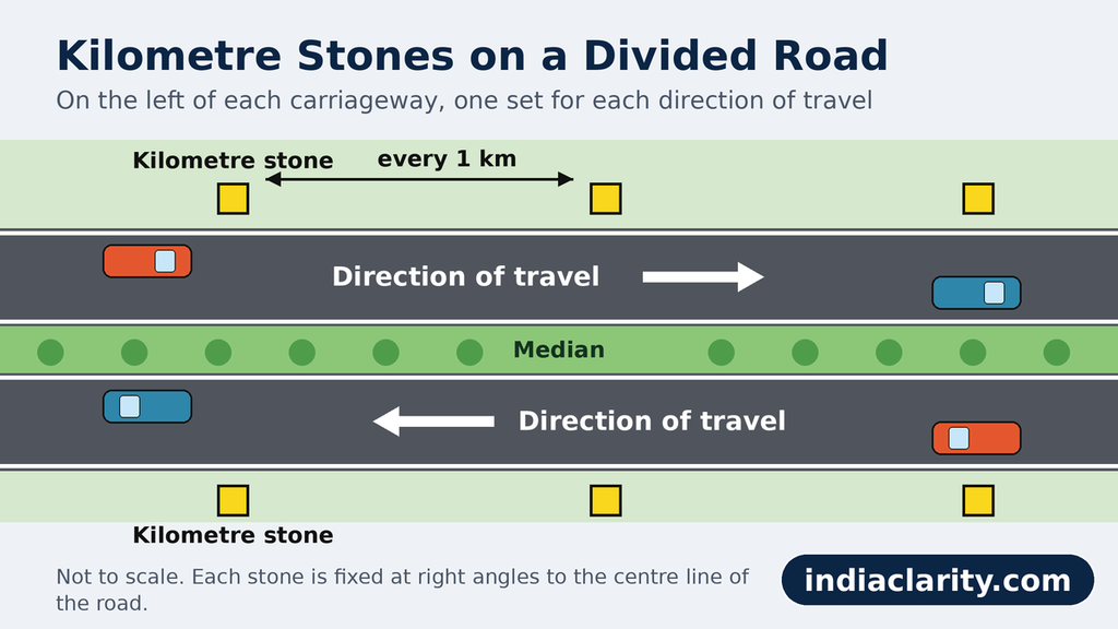
IRC:8 says stones should normally stand on the left side of the road as you travel away from the station where the count starts. On a divided road with a median, there are stones on the left of each carriageway, one set for each direction of travel. Every stone is fixed at right angles to the centre line of the road.
The code also says where to put them on difficult ground. On an embankment, the stone goes at the edge of the roadway beyond the shoulder, on a raised platform if needed. In a cutting, it is fixed clear of the shoulder and of the side drain, so that water and vehicles do not hit it.
Who really looks after your road
The colour tells you the class of the road. It does not tell you which department holds the broom. National highways show this best.
A national highway is one declared under the National Highways Act, 1956. The network now runs to about 1.46 lakh km, and a PIB release of 14 June 2026 puts it at 1,46,572 km. Many people assume NHAI looks after all of it. It does not. MoRTH’s annual report says the 16,125 km of national highways in the North-East alone are developed and maintained by four agencies: the state PWDs, the Border Roads Organisation, NHAI and NHIDCL. Of that length, 6,844 km is with NHIDCL and 6,787 km with the state governments.
Even on roads that NHAI manages, upkeep depends on the contract. PIB’s year-end review for 2025 says that out of the 1.46 lakh km network, works had been taken up on about 34,000 km, another 59,000 km was in the defect liability or concession period, and about 45,000 km was under maintenance contracts.
State highways are declared by the state government and are generally built and maintained through the state PWD. For the rest, the official road statistics list the state PWDs, zilla parishads, village panchayats and panchayat samitis as the bodies that look after them. District roads therefore depend a lot on how a particular state has set up its system, and village roads often sit with the panchayat.
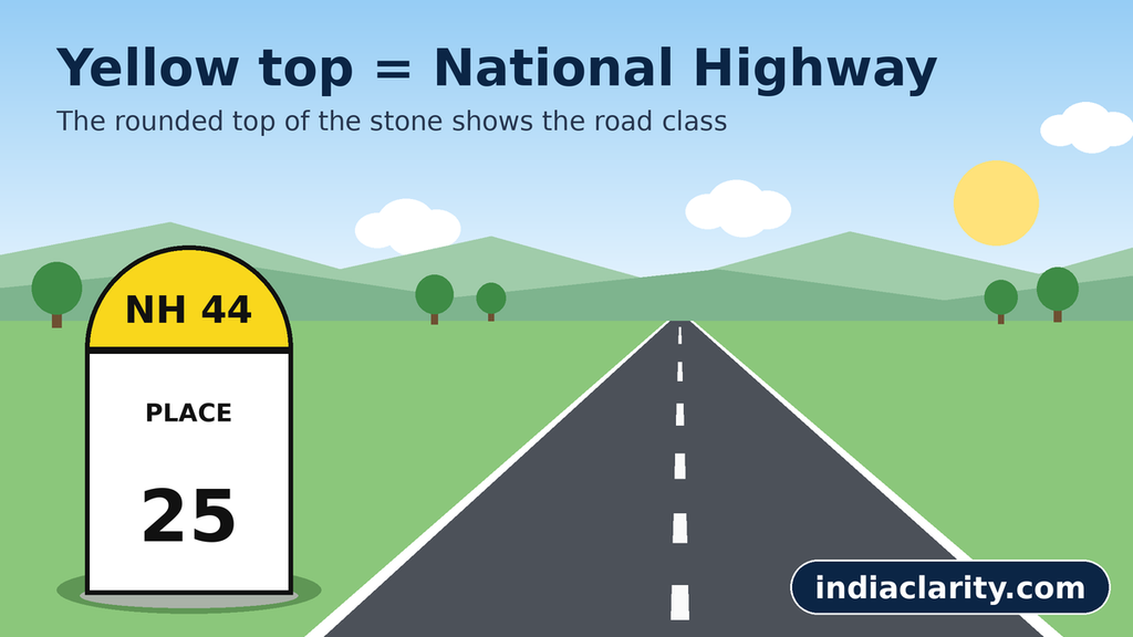
So when someone says yellow means NHAI, they are simplifying. Yellow means national highway. Which agency maintains your particular stretch is a separate question.
When the stone and the road disagree
The code is tidy. Roads are not. Three things regularly break the match.
Roads change class. When a state highway is declared a national highway, its stones need a new number and a new top colour. In a letter to state governments dated 25 October 2016, MoRTH said that the kilometre stones and 200-metre stones on national highways were still not showing the new national highway numbers. It also said that newly declared national highways still showed state highway numbers, that some stones were missing, and that the condition of many was very poor. If you want to know why the numbers changed in the first place, our article on how national highways are numbered explains it.
Paint fades. The Rural Roads Manual asks for kilometre, 200-metre and boundary stones to be painted twice a year and for wild growth around them to be cleared. That is the rule on paper. If a top looks pale, it may just be due for repainting, so do not read too much into a faded shade.
Older rules. Stones written before the 2004 circular may follow the earlier language pattern, as covered above.
The sensible habit is to treat the stone as a good clue and not as proof. Check it against a route marker sign or a map when it matters.
Read any stone in ten seconds
- Look at the rounded top: yellow, green, white or orange.
- Read the route number printed on it, if there is one.
- Read the town names and distances on the body.
- Check the number on the side facing the road. That is the stone’s own position along the road.
- If something looks odd, remember that roads change class and the stones can lag behind.
If you ever need to report an emergency or a road problem on a national highway, NHAI runs a toll-free helpline, 1033. Knowing the route number and the number on the nearest stone helps you describe where you are.
Frequently asked questions
What colour code is used for milestones on Indian highways?
IRC:8-1980 gives canary yellow for the rounded top on national highways, brilliant green on state highways and white on major district roads. Rural roads use orange, as set out in the Rural Roads Manual.
Why do milestones in India have different colours?
The colour is a quick label for the class of road you are on. The standard fixes one colour for each class, so the type of road can be read from the stone.
How can I identify a national highway and a state highway from the stone?
Look at the colour and the route number on the rounded top. A yellow top with a black number marks a national highway. A green top with a white number marks a state highway.
Which colour is used on roads built under PMGSY?
Orange. PMGSY’s type-design page asks for an orange rounded top on both ordinary and fifth-kilometre stones, and the same colour for boundary stones.
Read Also: How Vehicle Registration Numbers Work in India: What Each Part of MH 12 AB 1234 Means
Sources
- Indian Roads Congress, IRC:8-1980, Type Designs for Highway Kilometre Stones (Second Revision), archive.org copy
- Indian Roads Congress, IRC:SP:20-2002, Rural Roads Manual, archive.org copy
- PMGSY, Type Design for Ordinary Kilometer Stone, pmgsy.nic.in
- MoRTH circular dated 24 December 2004 on the use of language on kilometre stones and sign boards on national highways
- MoRTH letter dated 25 October 2016 on kilometre stones on national highways
- MoRTH circular dated 16 June 1981 on numbering of kilometre stones on national highways
- PIB, Ministry of Road Transport and Highways, Year End Review 2025 and Highways Transformation release of 14 June 2026
- MoRTH Annual Report (national highway agencies in the North-East)
- Ministry of Statistics and Programme Implementation, Statistical Abstract India, chapter on roads

Hi, I’m Aryan, the writer behind IndiaClarity. I write plain-language explainers on how India’s systems, places and history work. Before I publish, I check facts against primary sources such as official records, Parliament answers, Census data and Acts of law, and I list the sources at the end of each article. If you spot a mistake, write to me at 7brewusaofficial@gmail.com and I will fix it.
1 thought on “Milestone Colours on Indian Roads: What Yellow, Green, White and Orange Mean”