

At 2:30 pm on 24 May 2025, the India Meteorological Department (IMD) issued a press release saying the southwest monsoon had set in over Kerala, eight days ahead of the normal date of 1 June. The release did not say it had started raining. It listed three things the forecasters had looked at: how much cloud had built up over the sea, how deep and strong the westerly winds were, and how widely it had rained on the 23rd and 24th.
That is how IMD declares monsoon onset. Nobody sees the monsoon arrive. A team checks rain, wind and cloud against written rules, and when all three agree, the department makes the call. The date you read in the news is the date of that call. It is not the date of the first shower in your town, and it is not the day every part of Kerala turned wet.
The rules for Kerala are very precise. The rules for the rest of the country are looser, and the rules for the monsoon’s exit, and for its October cousin over Tamil Nadu, are different again. Here they are, one at a time.
Test one: rain at 14 stations
IMD does not average the rain over the whole state. It reads 14 fixed stations: Minicoy and Amini in Lakshadweep; Thiruvananthapuram, Punalur, Kollam, Alappuzha, Kottayam, Kochi, Thrissur, Kozhikode, Thalassery, Kannur and Kudulu in Kerala; and Mangalore on the Karnataka coast. Kudulu is in Kasaragod district (IMD’s own rainfall tables list it there), so it marks the northern end of the Kerala coast. IMD’s FAQ names “Kasargode” in the slot where the onset page says Kudulu, which looks like two names for the same corner of the coast.
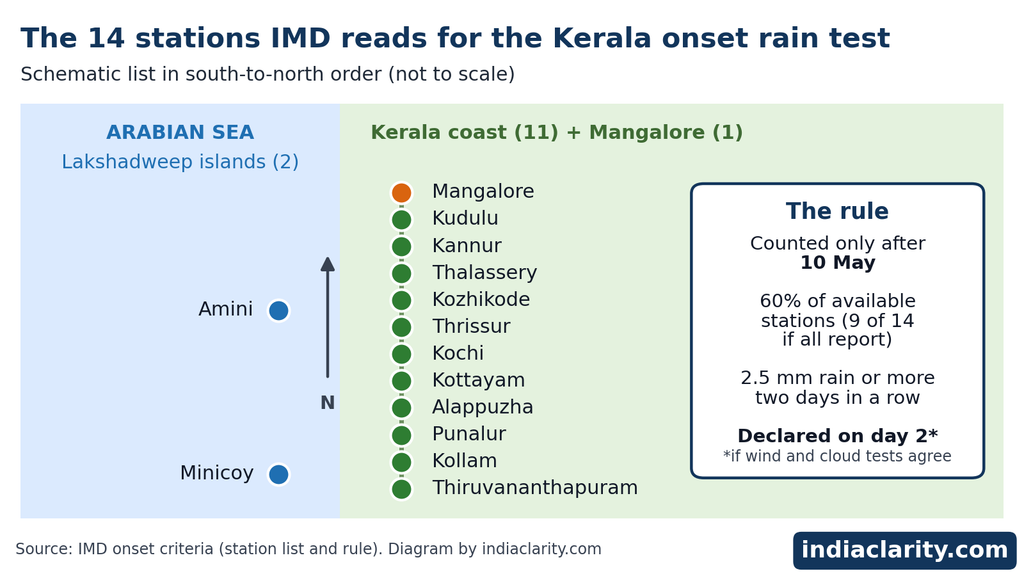
The rule, as IMD words it: after 10 May, if 60% of the available stations report 2.5 mm of rain or more on two days in a row, the onset over Kerala is declared on the second day, provided the wind and cloud conditions also agree. Four details in that sentence are easy to miss.
- 10 May is a starting gate. Rain before that date cannot trigger an onset, however heavy it is.
- 2.5 mm is a small amount. A light shower is enough for a station to count. The test asks how many stations got rain, not how hard it fell.
- The declared date is the second rainy day. So the announcement always comes a day after the first qualifying rain.
- “Available” matters. 60% of 14 is 8.4, so with all stations reporting, nine have to qualify. News reports often say eight. IMD’s page gives only the percentage and does not say how it rounds. If one station is missing, the count shifts: 60% of 13 is 7.8, which rounds up to eight.
Test two: westerly winds, deep and strong
At its core, a monsoon is a change in the wind. At onset the air over the sea off Kerala settles into a strong, deep flow from the west. IMD checks this with two readings over two boxes on the map.
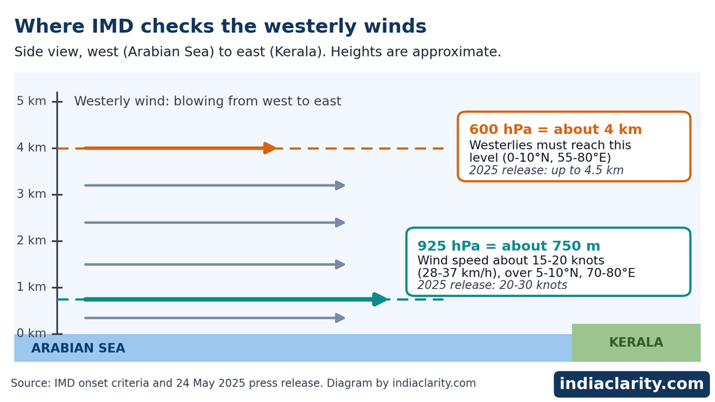
- Depth. Westerlies must reach up to the 600 hPa level in the box from the equator to 10°N and from 55°E to 80°E. That is a big patch of the Arabian Sea and the equatorial Indian Ocean.
- Speed. Over 5°N to 10°N and 70°E to 80°E, the west-to-east wind at the 925 hPa level should be of the order of 15 to 20 knots, which is roughly 28 to 37 km/h.
The hPa figures look odd until you know what they are. A hectopascal is a unit of air pressure, and pressure falls as you go up, so a level can be named by its pressure instead of its height. On a standard day 925 hPa sits about 750 metres above the sea and 600 hPa about 4 km up, though the exact heights drift a little with the weather. The wind figures come from wind analysis at the Regional Specialised Meteorological Centre (RSMC) or from winds derived from satellites, so no single instrument decides it.
Test three: cloud, seen from space
The third test uses outgoing longwave radiation, usually shortened to OLR. The ground and the air near it give off heat as longwave radiation. Over clear sky a lot of that heat escapes to space. Over tall, thick cloud the satellite sees the cold cloud tops instead and records less heat leaving, so a low OLR value means deep cloud.
IMD wants the INSAT satellite OLR value to be below 200 watts per square metre (200 W/m2) in the box 5°N to 10°N and 70°E to 75°E. That is open sea around Lakshadweep, west of the Kerala coast. OLR is not a rain measurement. It tells IMD that deep cloud has covered a wide patch of sea, which is what a moist monsoon flow pushing towards Kerala looks like from above.
A real announcement, checked against the rules
The 24 May 2025 release is a good place to see all this in practice, because it spells out what the forecasters saw.
| Test | IMD’s criterion | Reported on 24 May 2025 |
|---|---|---|
| Rain | 60% of 14 stations at 2.5 mm or more, two days running | Widespread rain on 23 and 24 May (the station tally is not printed) |
| Depth of westerlies | Up to 600 hPa (about 4 km) | Up to 4.5 km above sea level |
| Low-level wind | 15 to 20 knots at 925 hPa | 20 to 30 knots in the lower levels |
| Cloud (OLR) | Below 200 W/m2 | Below 200 W/m2 |
The rainfall annexure to the same release shows the jump in rain that IMD’s FAQ talks about. On 23 May the highest Kerala reading was 3 cm. On 24 May Kumarakom recorded 12 cm, and dozens of stations logged 5 cm or more.
Why IMD asks for all three
IMD’s FAQ says Kerala has used its current criteria since 2016, and describes the idea as a sharp rise in Kerala rainfall together with a large-scale monsoon flow and westerlies reaching 600 hPa. It does not say much more. The logic, as it reads to me, is that rain alone is easy to get from a local thunderstorm in May, while the depth of the wind and the cloud cover over the sea show that the large system has arrived. Rain tells IMD what is happening at the stations. Wind and cloud tell it whether the monsoon is behind it.
After Kerala, the checklist ends
Kerala is the only place with a numerical rule. For the rest of the country, IMD’s FAQ says onset and progress dates are declared operationally “in a subjective manner”: forecasters look for a sharp rise in rainfall that holds for a few days, along with matching changes in the winds.
The written guidelines add three things. A further advance is declared when rain occurs over parts of the meteorological sub-divisions, and the northern limit has to stay continuous, with no gaps. Forecasters also look at where the band of maximum cloud sits along the west coast on satellite images, and at water vapour images to see how far moist air has pushed in.
The result is the Northern Limit of Monsoon, or NLM: the farthest point north the monsoon has reached on a given day. IMD describes it as a string of coordinates and towns. On 24 May 2025 it ran from 13°N, 55°E in the Arabian Sea to Karwar on the Karnataka coast, crossed the peninsula through Shimoga and Dharmapuri to Chennai, and continued over the Bay of Bengal to Saiha in Mizoram and 27°N, 98°E. Mark those points on a map and the area south of that line is where the monsoon had advanced that day. The line usually moves in surges, with pauses in between.
One caution: the NLM is a declared limit, not a fence between wet and dry. Showers can fall north of it, and dry days can fall south of it, especially in the early surges.
Does an early or late Kerala onset say anything about the rest of the season? Meteorologists say there is no direct link between the Kerala date and the season’s total rainfall. A late Kerala onset usually means a late arrival over the southern states and Mumbai, but it does not automatically mean the northwest will be late.
The normal dates were rewritten in 2020
Every announcement is compared with a “normal date”, and those normals changed in 2020. The old ones came from records of just 149 stations between 1901 and 1940. IMD recalculated them using 1961 to 2019 data for onset and 1971 to 2019 data for withdrawal, and started using the new dates on 1 June 2020.
Kerala stayed at 1 June. Maharashtra, Gujarat, Madhya Pradesh, Chhattisgarh, Telangana, Andhra Pradesh, Odisha, Jharkhand, Bihar and parts of Uttar Pradesh got onset dates 3 to 7 days later. The extreme northwest went the other way: the monsoon is now expected to cover the whole country by 8 July instead of 15 July. Exit dates moved much more. Withdrawal from northwest India is now about 7 to 14 days later than before, while the final exit from south India stayed at 15 October.
| City | Normal onset: new (old) | Normal withdrawal: new (old) |
|---|---|---|
| Thiruvananthapuram | 1 Jun (1 Jun) | Not applicable: northeast monsoon takes over |
| Mumbai | 11 Jun (10 Jun) | 8 Oct (29 Sep) |
| Kolkata | 11 Jun (10 Jun) | 12 Oct (14 Oct) |
| Hyderabad | 8 Jun (7 Jun) | 14 Oct (15 Oct) |
| Ahmedabad | 21 Jun (14 Jun) | 30 Sep (22 Sep) |
| Bhopal | 22 Jun (15 Jun) | 30 Sep (20 Sep) |
| New Delhi | 27 Jun (23 Jun) | 25 Sep (22 Sep) |
| Jaipur | 1 Jul (23 Jun) | 22 Sep (12 Sep) |
| Jaisalmer | 8 Jul (15 Jul) | 17 Sep (1 Sep) |
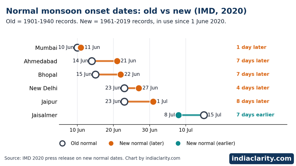
Read the table row by row. Delhi’s normal onset slid from 23 to 27 June and Jaipur’s from 23 June to 1 July, while Jaisalmer’s moved a week earlier, to 8 July. Jaisalmer’s exit date moved from 1 September to 17 September.
Check before you trust a number on any website: IMD’s own onset-criteria page still says the monsoon covers the entire country around 15 July, which is the pre-2020 figure. IMD’s FAQ and its 2020 release give 8 July.
The new normals were calculated with a separate set of objective rules built on daily gridded rainfall data, tuned to match IMD’s past operational dates. They produce the normal calendar. The live announcements still follow the Kerala checklist and the forecasters’ judgment described above.
Here is how a normal gets used. When the monsoon left Delhi on 23 September 2026, IMD’s release set that date against the normal of 25 September, and noted that the monsoon had reached Delhi on 2 July against a normal of 27 June. Since 1961, Delhi’s earliest exit was 3 September 1982 and its latest was 17 October 2013.
How far real years stray from 1 June
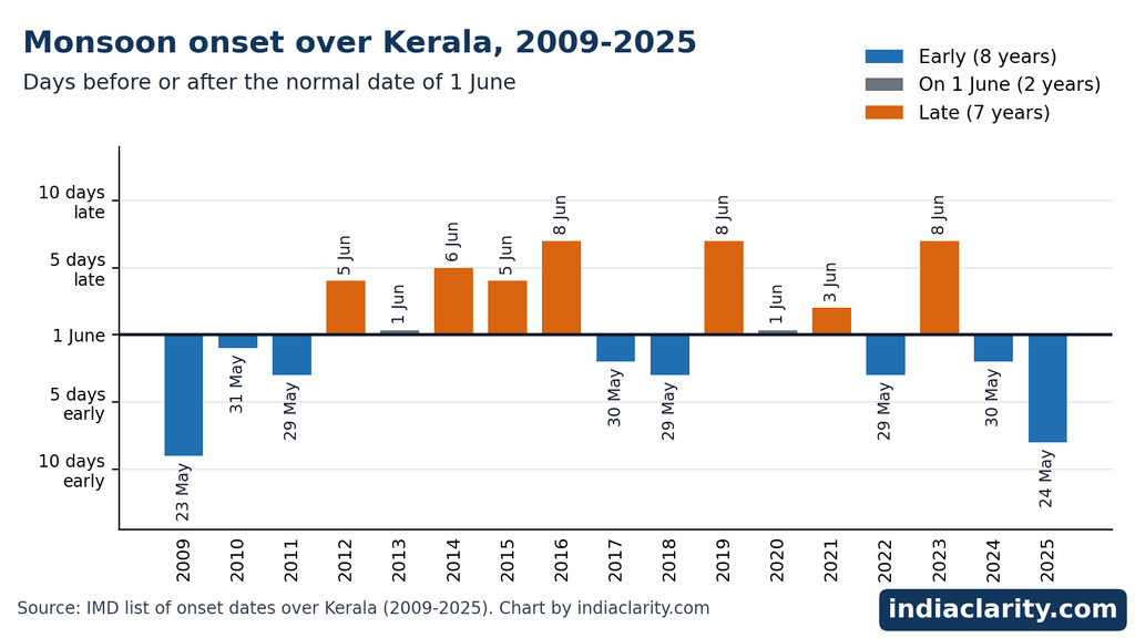
Normal is an average, and Kerala’s actual dates swing around it. IMD data quoted in news reports put the swing at about seven days either side (a standard deviation). Over 150 years the earliest onset was 11 May 1918 and the latest was 18 June 1972. This is what the last 17 years look like, from IMD’s own list.
| Year | Onset over Kerala | Days vs 1 June |
|---|---|---|
| 2009 | 23 May | 9 days early |
| 2010 | 31 May | 1 day early |
| 2011 | 29 May | 3 days early |
| 2012 | 5 June | 4 days late |
| 2013 | 1 June | On the day |
| 2014 | 6 June | 5 days late |
| 2015 | 5 June | 4 days late |
| 2016 | 8 June | 7 days late |
| 2017 | 30 May | 2 days early |
| 2018 | 29 May | 3 days early |
| 2019 | 8 June | 7 days late |
| 2020 | 1 June | On the day |
| 2021 | 3 June | 2 days late |
| 2022 | 29 May | 3 days early |
| 2023 | 8 June | 7 days late |
| 2024 | 30 May | 2 days early |
| 2025 | 24 May | 8 days early |
Eight of those years were early, two landed on 1 June and seven were late. 2025 was the earliest since 2009.
IMD also issues a forecast of the onset date in mid-May, which is a separate exercise from the declaration. It usually carries an error margin of 4 days either way. For 2019 to 2023 the forecasts were 6 June, 5 June, 31 May, 27 May and 4 June, and the declared dates were 8 June, 1 June, 3 June, 29 May and 8 June. IMD says its onset forecasts for 2005 to 2023 proved correct in every year except 2015.
How IMD declares the monsoon has left
The exit has its own rules, and they are written more loosely than the entry rules.
- Not before 1 September. IMD does not attempt withdrawal from the extreme northwest earlier than that.
- First withdrawal from western parts of northwest India needs three signs: no rain over the area for five days in a row; an anticyclone (a clockwise-turning high-pressure circulation in the northern hemisphere) established in the lower atmosphere at 850 hPa and below; and a clear fall in moisture, read from satellite water vapour images and tephigrams (charts drawn from weather-balloon readings that show how temperature and moisture change with height).
- Further withdrawal is declared by keeping the withdrawal line continuous, with falling moisture on the water vapour images and five dry days.
- Withdrawal from the southern peninsula, and so from the whole country, comes only after 1 October, when the winds change over from the south-westerly pattern.
Notice the difference from the entry rules. Onset has thresholds with units. The exit has one hard number, five dry days, and the rest is judged from images and charts, with phrases like “considerable reduction” in moisture.
The normal dates, from the table above, are about 17 September for the first exit from the northwest and 15 October for the last exit from the south. Real years wander. In 2020 the first withdrawal from west Rajasthan came on 28 September, 11 days after the normal date.
The October announcement: the northeast monsoon
When the southwest monsoon leaves the south, a different wind takes over. The northeast monsoon brings the October to December rain to the Tamil Nadu coast and nearby areas, and IMD declares its onset too. According to IMD’s monograph on onset and withdrawal, the criteria were framed in 1988 and amended in 2006:
- The southwest monsoon has withdrawn up to latitude 15°N.
- Persistent surface easterly winds have set in over the Tamil Nadu coast.
- The easterlies reach up to 850 hPa over the Tamil Nadu coast.
- Rainfall is fairly widespread over coastal Tamil Nadu, south coastal Andhra Pradesh and neighbouring areas.
IMD’s records for 1977 to 2020 put the average onset on 22 October, give or take about seven days. The earliest was 5 October in 1984, and the latest was 2 November, which happened in 1988, 1992 and 2000. The season lasts about 75 days on average, with the shortest at 51 days (1992) and the longest at 98 days (2005). IMD began announcing an end date for this monsoon only in 1993, and the monograph says no objective criteria for it have been published.
The first criterion creates a knot. If the southwest monsoon has not formally withdrawn to 15°N, IMD cannot declare the northeast onset in real time, even when the other three conditions are met. That is why the two often arrive in one statement. In October 2024, for example, IMD said the southwest monsoon had left the whole country and that northeast monsoon rain had begun over the south-east peninsula, in a single announcement.
IMD’s own scientists have tested how well these dates hold up. The monograph proposes a stricter method (a proposal, not an official rule) that looks at rain at 25 gauge stations along the Tamil Nadu and south Andhra coast, the 850 hPa easterly winds and OLR together. Run over 1981 to 2020, it gives the same onset date as IMD’s announced one in 14 years, differs by about 2 days on average, and differs by 10 days or more in five years: 1984, 1987, 2000, 2001 and 2020.
2020 shows why. IMD declared the onset on 28 October. On that day only 14% of the 25 reference stations had recorded 2.5 mm or more, OLR was above 240 W/m2, which means little cloud, and weak easterlies had only just set in. Not much rain followed until 12 November, and the monograph’s method puts the onset on 13 November. For 1986, in comparison, the method gives 26 October, when 63% of the stations had rain. IMD’s date that year was 27 October.
None of this makes the 28 October call careless. A declaration is made on the day, with the maps and observations available that day. The monograph’s check had decades of data and the days that followed to look at. What it does show is that for the northeast monsoon the announced date is a forecaster’s best reading, and it can sit a couple of weeks away from what a stricter rule would give.
Reading IMD’s announcements yourself
IMD’s press releases use a fixed vocabulary. Once you know the phrases, you can follow the monsoon without waiting for the news.
- “Has set in over Kerala” is the onset declaration itself.
- “Has further advanced into…” lists the new areas that are now inside the Northern Limit of Monsoon.
- “Conditions are favourable for further advance” is the forecasters’ expectation for the next few days. It is a forecast, not a declaration.
- “The line of withdrawal passes through…” is the exit version of the NLM. IMD’s releases of 8 and 9 October 2026 describe the line as passing through places including Supaul and Ranchi, with more withdrawal expected from eastern India and the northern peninsula.
The Monsoon section of IMD’s website carries the progress and withdrawal pages, the daily activity map and the criteria pages quoted in this article. Press releases are filed separately.
Read Also: How Mountain Height Is Measured in India: What “8,848 Metres” Really Means
Sources and where to check
All figures above were checked against these IMD documents on 12 October 2026. Normal dates and station lists can be revised, so check the current page before quoting them.
- IMD: Onset and advance of monsoon (criteria)
- IMD: Withdrawal of southwest monsoon (criteria)
- IMD: Frequently asked questions on monsoon (PDF)
- IMD: New normal dates of onset and withdrawal, 2020 press release (PDF)
- IMD: Press release of 24 May 2025 on monsoon onset over Kerala (PDF)
- IMD: Forecast of the onset date over Kerala, 2024 press release (PDF)
- IMD: Chapter 5, Onset and withdrawal (northeast monsoon) (PDF)
- IMD New Delhi: Withdrawal of southwest monsoon from Delhi, 23 September 2026 (PDF)

Hi, I’m Aryan, the writer behind IndiaClarity. I write plain-language explainers on how India’s systems, places and history work. Before I publish, I check facts against primary sources such as official records, Parliament answers, Census data and Acts of law, and I list the sources at the end of each article. If you spot a mistake, write to me at 7brewusaofficial@gmail.com and I will fix it.