

A PIN code looks like one six-digit number, but each part of it carries different routing information. The first digit identifies the postal region, the second narrows it to a sub-region, the first three digits together identify a sorting district, and the last three identify the delivery post office.
Take 560001 as an example. The first digit, 5, places it in the southern postal region. The first two digits, 56, point to the Karnataka postal range, the first three digits, 560, identify the Bengaluru sorting district, and 001 identifies the delivery office.
Once you understand that pattern, a PIN becomes much easier to read. The tables below show how the system is organised and how you can use it to make sense of a PIN.
Why India Needed PIN Codes
When India became independent, it had 23,344 post offices, most of them in towns and cities, according to Department of Posts figures reported in historical records.
The postal network expanded rapidly after Independence. Sorting mail became increasingly difficult because addresses could be written in different languages and spellings, while many towns and villages shared similar names.
A sorting clerk dealing with an address such as “Rampur” could not rely on the place name alone. A standard numerical system made it easier to route mail without depending entirely on how an address was written.
The Postal Index Number (PIN) system was introduced on 15 August 1972. It created a six-digit system that added routing information to an address and helped postal staff sort mail more efficiently.
What Each Digit of a PIN Code Means
Read a PIN from left to right and each part narrows the postal area a little further.
- 1st digit — postal region: India is divided into postal regions represented by the first digit.
- 2nd digit — sub-region: The second digit narrows the area within that region and, together with the first digit, helps identify a particular postal area.
- First 3 digits — sorting district: The first three digits together identify the central sorting district.
- Last 3 digits — delivery post office: The final three digits identify a particular delivery post office within that sorting district.
This is why a PIN is more than a random six-digit number. Its structure was designed to provide routing information as mail moves through the postal network.
The Nine PIN Zones
The first digit gives the broadest geographical clue.
| First digit | Part of India | States and union territories |
|---|---|---|
| 1 | North | Delhi, Haryana, Punjab, Himachal Pradesh, Chandigarh, Jammu and Kashmir, Ladakh |
| 2 | North | Uttar Pradesh, Uttarakhand |
| 3 | West | Rajasthan, Gujarat, Dadra and Nagar Haveli and Daman and Diu |
| 4 | West | Maharashtra, Goa, Madhya Pradesh, Chhattisgarh |
| 5 | South | Andhra Pradesh, Telangana, Karnataka |
| 6 | South | Tamil Nadu, Kerala, Puducherry, Lakshadweep |
| 7 | East | West Bengal, Odisha, Assam and other northeastern states, Sikkim, Andaman and Nicobar Islands |
| 8 | East | Bihar, Jharkhand |
| 9 | Army | Army Postal Service and Field Post Offices |

The first eight zones broadly correspond to geographical regions. Zone 9 is different because it is associated with the Army Postal Service and Field Post Offices rather than a particular geographical region.
These zones are useful for understanding the general structure of a PIN, but they should not be treated as exact political or administrative boundaries.
State-Wise PIN Prefixes
The first two digits usually provide a quick indication of the state or postal area, although some ranges are shared and some smaller states or union territories fall within larger postal ranges.
| PIN starts with | State or union territory |
|---|---|
| 11 | Delhi |
| 12–13 | Haryana |
| 14–15 | Punjab |
| 16 | Chandigarh |
| 17 | Himachal Pradesh |
| 18–19 | Jammu and Kashmir, Ladakh |
| 20–28 | Uttar Pradesh, Uttarakhand |
| 30–34 | Rajasthan |
| 36–39 | Gujarat |
| 40–44 | Maharashtra |
| 45–48 | Madhya Pradesh |
| 49 | Chhattisgarh |
| 50 | Telangana |
| 51–53 | Andhra Pradesh |
| 56–59 | Karnataka |
| 60–66 | Tamil Nadu |
| 67–69 | Kerala |
| 70–74 | West Bengal |
| 75–77 | Odisha |
| 78 | Assam |
| 790–792 | Arunachal Pradesh |
| 793–794 | Meghalaya |
| 795 | Manipur |
| 796 | Mizoram |
| 797–798 | Nagaland |
| 799 | Tripura |
| 80–85 | Bihar, Jharkhand |
| 90–99 | Army Postal Service |
Some smaller states and union territories are identified within the ranges of larger neighbouring postal areas. For example, Goa uses PINs beginning with 403, Sikkim uses 737, and the Andaman and Nicobar Islands use 744. Puducherry has PINs beginning with 605, while Lakshadweep uses the 682 range.
This is one reason a PIN should be treated as a postal routing system rather than a direct map of India’s political boundaries.
Reading Real PIN Codes
Here are six familiar PINs and the post offices they identify.
| PIN | Zone | Sub-region | Sorting district | Delivery office |
|---|---|---|---|---|
| 110001 | 1 (North) | 11 (Delhi) | 110 (Delhi) | 001: New Delhi GPO |
| 400001 | 4 (West) | 40 (Maharashtra) | 400 (Mumbai) | 001: Mumbai GPO |
| 560001 | 5 (South) | 56 (Karnataka) | 560 (Bengaluru) | 001: Bengaluru GPO |
| 600001 | 6 (South) | 60 (Tamil Nadu) | 600 (Chennai) | 001: Chennai GPO |
| 700001 | 7 (East) | 70 (West Bengal) | 700 (Kolkata) | 001: Kolkata GPO |
| 403001 | 4 (West) | 40 (Maharashtra postal range) | 403 (Goa) | 001: Panaji Head Office |
What About PIN Code 400023?
PIN 400023 falls within the Mumbai postal range. The first digit, 4, places it in the western region, while 40 is associated with the Maharashtra postal range and 400 with the Mumbai sorting district.
The final three digits, 023, identify the particular delivery office. To find the exact office and locality served by that PIN, it is better to use India Post’s official PIN search rather than trying to infer the neighbourhood from the digits alone.
How to Read Any PIN in Three Steps
You can make a quick first-level interpretation of most Indian PIN codes by following three steps:
- Check the first digit to identify the broad postal region.
- Check the first two digits to identify the relevant postal range.
- Check the first three digits to identify the sorting district.
The final three digits identify the delivery post office and generally cannot be decoded from a simple mathematical rule. If you need the exact office, use an official India Post lookup.
How a Letter Finds Its Destination
A PIN helps postal workers route mail through the postal network.
A simplified journey looks like this:
- The letter or parcel is accepted at a post office and enters the postal network.
- The first three digits provide information used to identify the relevant sorting district.
- Mail is sorted and sent towards the destination district when it is not meant for the local area.
- At the destination, the final three digits identify the delivery post office.
- The delivery office then handles the final stage of delivery using the rest of the address.
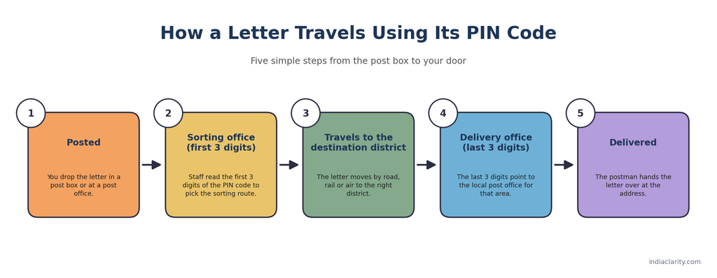
The PIN therefore works together with the street address, locality, house number and other address details. It does not replace the rest of the address.
What a PIN Code Does Not Tell You
One PIN Can Cover Many Places
A PIN is associated with a delivery post office, and several branch or sub offices can operate under the same PIN.
This means a single PIN can cover multiple localities or villages. In rural areas, the area served by one delivery office can be particularly broad.
The reverse can also happen: a densely populated urban area may have several delivery offices and therefore several PIN codes.
A Sorting District Is Not a Government District
A postal sorting district exists to help organise and route mail. It does not necessarily follow the boundaries of an administrative district.
This distinction matters because a government district and a postal sorting district have different purposes. A government district is part of the administrative system, while a postal sorting district is part of the system used to process and route mail.
If you want to understand how an administrative district works and what a district administration does, see our separate guide on how a district works in India.
Nearby Places Can Have Different PIN Codes
PIN codes are based on the postal delivery network, not simply on geographical distance.
Two houses that are close to each other can sometimes be served by different delivery offices and therefore have different PIN codes. Conversely, places that are relatively far apart can share a PIN when they fall under the same delivery network.
This is why guessing a PIN from a nearby address is not always reliable.
DIGIPIN: A 10-Character Code for Exact Locations
A PIN code identifies the delivery area of a post office. It does not provide a precise geographic reference for a particular location.
DIGIPIN is a newer addressing system developed by the Department of Posts in collaboration with IIT Hyderabad and the National Remote Sensing Centre (NRSC), ISRO.
India Post describes DIGIPIN as a nationwide geo-coded addressing grid. It divides India’s geographical area into approximately 4-metre by 4-metre grid squares, with each grid assigned a unique 10-character alphanumeric code based on latitude and longitude.
The idea is different from a traditional postal PIN. A PIN is connected to the postal network, while DIGIPIN represents a geographic location.
PIN Code vs DIGIPIN
| PIN code | DIGIPIN | |
|---|---|---|
| Length | 6 digits | 10 alphanumeric characters |
| What it represents | Delivery post office and postal service area | A geographic grid location |
| Based on | Postal network | Latitude and longitude |
| Precision | Broad postal area | Approximately 4m × 4m grid |
| Main purpose | Postal routing | Digital location-based addressing |

DIGIPIN can be particularly useful where conventional addresses are difficult to describe or where a precise geographic reference is needed.
India Post says that DIGIPIN complements traditional addresses rather than replacing them. Your existing postal address does not change simply because a DIGIPIN is associated with a location.
The official DIGIPIN system is also designed to work offline once the relevant code-generation logic is available. The accuracy of a DIGIPIN obtained through a device, however, depends partly on the accuracy of the device’s location information.
How to Find Your DIGIPIN
India Post provides a Know Your DIGIPIN web application. You can open the tool on a device with location access enabled and allow it to determine your location.
You do not need to create an account simply to obtain the DIGIPIN for your location.
Because the result depends on your device’s location reading, the displayed location should be checked carefully when precision matters.
How to Check the Correct PIN Code for an Address
If you are unsure about the PIN for an address, use India Post’s official PIN search rather than relying on a third-party directory.
India Post provides search options that allow users to find a PIN or post office using details such as the state, district or post office name.
When checking an address, use the PIN of the delivery office that actually serves the address, rather than automatically choosing the nearest post office on a map.
This distinction can matter because the nearest post office is not always the office responsible for delivering mail to a particular street or locality.
Frequently Asked Questions
What do the six digits of a PIN code mean?
The six digits provide postal routing information. The first digit identifies the broad postal region, the second narrows the area to a sub-region, the first three digits together identify the sorting district, and the last three identify the delivery post office.
Why does India have a six-digit PIN code?
The six-digit system was introduced in 1972 to make postal sorting and routing more systematic. Its structure provides several levels of routing information within a compact numerical code.
Which area does PIN code 400023 belong to?
PIN 400023 falls within the Mumbai postal range. The first three digits, 400, identify the Mumbai sorting district, while the final three digits identify the particular delivery office. The exact locality should be confirmed through India Post’s official PIN search.
How can I decode an Indian PIN code?
Start with the first digit to identify the broad postal region. Then check the first two digits for the relevant postal range and the first three digits for the sorting district. The final three digits identify the delivery post office and should be checked through an official lookup when you need the exact office.
Can two different places have the same PIN code?
Yes. Multiple localities, villages, branch offices or sub offices can fall under the same delivery network and use the same PIN.
Why do nearby places sometimes have different PIN codes?
PIN codes follow postal delivery arrangements rather than simple geographical distance. Two nearby locations can be served by different delivery offices.
What is the difference between a PIN code and DIGIPIN?
A PIN code is part of India’s postal routing system and identifies a delivery post office and its service area. DIGIPIN is a location-based digital addressing system that represents an approximately 4m × 4m geographic grid.
Will DIGIPIN replace PIN codes?
India Post currently describes DIGIPIN as a complementary digital addressing layer rather than a replacement for traditional postal addresses. Its role is to provide more precise location information alongside existing addressing systems.
The Short Version
A PIN code narrows a postal destination in stages. The first digit gives the broad region, the second helps narrow the postal area, the first three identify the sorting district, and the last three identify the delivery post office.
That structure helps the postal system route mail efficiently, but the PIN is only one part of a complete address.
DIGIPIN takes a different approach. Instead of identifying a postal delivery area, it represents a precise geographic grid location. The two systems therefore serve different purposes and can work alongside each other.
Sources
- Postal Index Number, Wikipedia (summarises the PIN structure, zones and prefixes, with references to India Post material)
- India Post: DIGIPIN page and FAQs (Department of Posts, reviewed August 2026)
- DIGIPIN Technical Document (Department of Posts)
- The Indian Express, August 2022, on the history of the PIN code (citing the Department of Posts)
- Onmanorama, May 2026, on the India Post digital ID pilot

Hi, I’m Aryan, the writer behind IndiaClarity. I write plain-language explainers on how India’s systems, places and history work. Before I publish, I check facts against primary sources such as official records, Parliament answers, Census data and Acts of law, and I list the sources at the end of each article. If you spot a mistake, write to me at 7brewusaofficial@gmail.com and I will fix it.
7 thoughts on “How PIN Codes Work in India: What Each of the 6 Digits Means”